
Tuesday, December 28, 2010
Wednesday, December 01, 2010
Vol. 1 No 2 of the Journal of Agricultural Informatics has been published
From our daily mail. Prof. Dr. Miklós Herdon sent the following circular this evening:
 " Dear Colleague,
I inform you that the Vol 1, No 2 (2010) of the Journal of Agricultural
Informatics has been published.
The articles are accessible in the on-line journal system.
http://journal.magisz.org/
The edited issue can be downloaded from:
http://journal.magisz.org/
Miklos Herdon
president of HAAI
_______________
Agrárinformatika Folyóirat / Journal of Agricultural Informatics
http://journal.magisz.org/
HUNAGI encourages its members and partners to publish original articles in the high-level on-line scientific journal.
HUNAGI Comments on the Digital Hungary 2010-2014 Public Discussion Paper

Presentations of the SDI 2010 Conference in Skopje are available
From our daily mail: Downloadable ppts of the Regional SDI Conference held in Skopje, Macedonia!
 "Dear authors of papers in the International Conference SDI 2010 – Skopje (http://sdi2010.evkartenn.com)
It is my pleasure to inform you that all papers published in proceedings are available at OICRFs web page (www.oicrf.org) also, free downloadable.
Looking forward to meet you ASAP.
Sincerely yours,
==========
INTERNATIONAL CONFERENCE ON SDI 2010
15-17 September 2010 - SKOPJE sdiconf2010@gmail.com
http://sdi2010.evkartenn.com"
INTERNATIONAL CONFERENCE ON SDI 2010
15-17 September 2010 - SKOPJE sdiconf2010@gmail.com
http://sdi2010.evkartenn.com"
GeoAdat Conference on Earth Observation completed successfully

Photo coverage: picasaweb.google.com/hunagialbums
HUNAGI participated the Plan4all@GDI.at Workshop of AGEO

Photo coverage: picasaweb.google.com/hunagialbums
Wednesday, November 10, 2010
GeoInt Conferences in Budapest and Doha (Quatar)


Discussion Paper on Digital Hungary - 2010-2014
The official document is downloadable from the website of the National Development Ministry.
GSDI Statement announced at the GEO Ministerial Summit in Beijing
Text will be available soon by clicking on the header.
GSDI intervention related to the Data Sharing Action Plan Discussion at the GEO-VII Plenary
Text will downloadable by clicking on the header asap
Sunday, October 31, 2010
Flyer for the GEO-VII on recent Hungarian Earth Observation activities

Organised by HUNAGI member GeoAdat Ltd and supported by the European Space Agency's PECS program a full-day Workshop will be arranged in Budapest with active participation of ESA and Hungarian experts. The flyer on the event's program will be disseminated at the GEO-VII in Beijing next week.
Tuesday, October 19, 2010
GSDI Workshops
Nine parallel workshops and 5 technical meetings were organized for the morning of the Opening Ceremony of the GSDI-12 Conference. Two of them were visited by HUNAGI representative as follow: Workshop 3: Information Policy Best Practices presented by Roger Longhorn as well as Workshop 7: Elements of a legal framework for Effective SDI orchestrated by Roger Longhorn, with lecturers Katleen Janssen of K.U.Leuven on the Data sharing aspects, Leila Aslesen of Statens Kartwerk on the EURADIN project and Anne Fitzgerald of University of Queensland, Brisbane on Open licensing as a driver of access and reuse policy and practice.
Thursday, October 14, 2010
Interspect-Greenpeace aerial survey - Newest imageries
Explanation text in Hungarian (translation service provided): please click on the header
© Interspect - Greenpeace
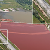
Mud pollution in Hungary - SAFER in action

Credit: SAFER/DLR
Monday, October 11, 2010
INTERSPECT surveys above Kolontár and the Aluminum-plant reservoir

Mr. Bakó wrote recently: "We have been exploring the over expanding opencast mining and dumps that are potentially dangerous or simply are not in appropriate condition since the spring of 2010. The activity of public utility has been going on slowly as we have been doing it for our own objectives.
We have proposed the application of a remote sensing system (involving a complex aerial photography procedure) developed in the last half a year for the survey of environmentally and areas dangerous for human lives. We took photos of the area of the disaster as well on 11th and 12th June (see picture 1). Concerning the condition of the object some doubt ariose, but we were informed that it was under continuous control and we had no right to doubt the procedure. At present a remote sensing system cannot criticize investigations on the premises.
In our opinion the potentially dangerous objects in Hungary could be photographed within up to two weeks and thus an order of importance concerning danger, a kind of prioritization, a ranking on the basis of instrumental examinations could be made according to the immediacy of intervention, so that such deadly disasters would not happen again.
We are still looking for the financial facilities to make this method even more effective and to carry out the examinations faster. There is a great possibility that such disasters can be prevented if the renovation of such establishments is carried out in time and in the right order. Pictures 2, 3, 4 and 5 were taken two days after the disaster."
 |
To see the full picture please click on it.
Images: © INTERSPECT - Bakó Gábor
Images: © INTERSPECT - Bakó Gábor
Red sludge flood caused the worst ecological disaster in the history of Hungary
Manager of the HUNAGI Member organisation Gotmaps? Ltd (Ohio, USA) Mr. Gábor Barsai called our attention on the e-media MSNBC which published a comprehensive, richly illustrated cover paper on the worst ecological disaster in the history of Hungary. For details please click on the header.
Wednesday, October 06, 2010
UN-SPIDER Newsletter September 2010
From our daily mail. Ms. Natalie Epler, expert of the United Nations Platform for Space-based Information for Disaster Management and Emergency Response sent the following letter this evening:
"We are pleased to publish the UN-SPIDER September 2010 Newsletter. Ourperiodic Newsletters contain news on recent UN-SPIDER activities. This publication is directly accessible at:
http://www.un-spider.org/
In this issue:
SpaceAid
Pakistan: space-based information at the service of relief operations
Outreach
Working towards a Plan of Action for Africa: UN-SPIDER Regional Workshop
in Addis Ababa
UN-SPIDER meeting with National Disaster Coordinating Council in
Philippines
JBGIS and UNOOSA publish “Geoinformation for Disaster and Risk Management
- Best Practices and Examples”
Network
RCMRD in Nairobi establishes ninth Regional Support Office
Interview
with Dr. Iván Darío Gómez Guzmán, Director General of the Agustín Codazzi
Geographic Institute and Executive Secretary of the Colombian Space
Commission
Case Study
Flood monitoring by Ukraine Space Research Institute"
Tuesday, October 05, 2010
HUNAGI's contribution to the Annual Report of the Hungarian NMCAs
The Hungarian Association for Geo-information (HUNAGI) is a non-for-profit umbrella organisation serving the spatial data interest community in Hungary since 1994. Its major objectives are to encourage and facilitate the availability, accessiblity and usability of geographic information according to the INSPIRE legislation framework. To achieve these goals, using its European and global relations emphasis is given to awareness raising, dissemination of knowledge and best practices in association with EU directives INSPIRE and PSI. also enabling Having about 100 member institutions and organisations, HUNAGI’s multidisciplinary community includes governmental agencies, NGOs, academic and private sector. The Hungarian Mapping and Cadastral Agencies are well represented in HUNAGI since the beginning. Some recent activities and features include:
· Links and joint actions with non-member NGOs: partnership with ITS Hungary (navigation), MLBKT (Hung. Society of Logistics, Purchase and Inventory), MAGISZ (Hungarian Society of Content Industry), CASCADOSS Hungary Association, Hungarian Space Research Cluster (HUNSPACE), as well as the SZVT (Hung. Society of Management and Organisation).
· Recently, HUNSPACE and HUNAGI elaborated and submitted a proposal for the Ministry of National Development on a New Space Strategy emphasizing the ESA membership and the role of the SMEs in space industry and space applications using EO and GNSS technologies
- Promoted by HUNAGI two Hungarians became founding members of the International Geospatial Society (IGS), the organisation established by GSDI Association for individual experts worldwide.
- As far as the international links and activities of HUNAGI during the past year is concerned, four entities should be mentioned: EUROGI, GSDI, ISDE and UNGIWG.
HUNAGI joined EUROGI, the European Umbrella Organisation of Geographical Information in 1996. Between 1998-2000 it had seat in the Executive Committee. Some of the major actions since August 2009 are as follow:
- Organising EUROGI ExCom Meeting hosted by VÁTI, member of HUNAGI in Budapest
- EUROGI supported the first HUNAGI Conference on Geospatial OSS with best practice from Portugal (OGC, DG Info, EU Humboldt project were presented too)
- Participating at the EUROGI Members‘ Day and Annual General Meeting in Brussels hosted by IGN
- Preparation of a comprehensive calendar for EUROGI of GI/SDI-related events in the CEE-SEE Countries for 2010-2011
- Bilateral consultations with CAGI on possible joint actions (e.g. Urban planning and GIS, Exhibition, implemented by the Hungarian Urbanistical Society at the Budapest Corvinus University) and considering opportunities provided by the Visegrad framework
- Based on the suggestion of HUNAGI, EUROGI is ready to co-organize a conference during the Hungarian EU presidency in a topic (European best practice in SDIs, self assessment methodology), which is in line with the host institutions‘ interest. Referring the MoU driven EUROGI-Eurogeographics cooperation a joint one day conference might be considered if the readiness to host is expressed by the Hungarian relevant authorities.
HUNAGI joined GSDI, the Global Spatial Data Infrastructure Initiative and later Association in 1996. Since 1998 it has seat in the Advisory Committee, later Executive Committee. The mandate has expired in 2009. Some of the major actions since August 2009 are as follow:
- Representing GSDI Association by presentation at the CEOS WGISS-29 Meeting in Bonn hosted by OOSA SPIDER, (WGISS is for Working Group on Information Systems and Services of the Committee on Earth Observation),
- Co-chairing the GSDI Legal & Socioeconomic Committee,
- Preparation for the GSDI-12 Conference scheduled for October 2010,
- Alternate Head of the GSDI Delegation attending the GEO-VII Plenary and Ministerial Summit in Beijing
By invitation, HUNAGI joined UNSDI, the United Nations Spatial Data Infrastructure Initiative after The Netherlands and the Czech Republic as third country coordinator in 2006. This initiative was orchestrated and supervised by the UN Geographic Working Group (UNGIWG). Since 2007 as partner, HUNAGI is invited to take part the UNGIWG Meetings, which is a forum of delegated experts from about 30 UN agencies and some NGOs.
Some of the major actions since August 2009 are as follow:
- Conference on Disaster Management using satellite based technologies and UNGIWG-10 Anniversary Plenary hosted by OOSA in the SPIDER Office in Bonn, where the VINGIS poster of FÖMI was also displayed.
- HUNAGI promotes UNGIWG and UNSDI/SPIDER actions regularly in English at the HUNAGI/UNSDI newsblog: http://unsdihu.blogspot.com
For actions related to any abbrevation above, please use the blog‘s search function.
HUNAGI joined ISDE, the International Digital Earth Initiative – later International Society of Digital Earth - in 2003. Since 2008 it has seat in the Executive Committee. Some of the major actions since August 2009 are as follow:
- Participatied the ISDE-6 Symposium and ExCom Meetings and contributed to the Beijing Declaration directly emphasizing the role of SDI and technologies such as sensorwebs, RFID and LBS.
- HUNAGI representative was invited to and voted by the Editorial Board of the International Journal of Digital Earth (IJDE) which is registered by the Thompson Science Citation Index in its third year!
- Taking part the brainstorming hosted by the DG JRC in the subject Europe and the Digital Earth inviting the European ExCom members of ISDE and other prominent experts.
- Participated the 3nd Digital Earth Summit devoted to „Digital Earth In The Service Of Society:
Sharing Information, Building Knowledge“ and organised by the Sofia University of Architecture,
Civil Engineering and Geodesy in conjuction with ISDE and EC DG JRC.
- Recent meetings with the Director General of the Department of Land Administration of the Ministry of Rural Development as well as the Director General of the Institute of Geodesy, Cartography and Remote Sensing (FÖMI) promoting the opportunity to host the ISDE-8 in Budapest in 2013.
Other international networking activity of HUNAGI includes:
Taking part in the following European projects: EURADIN (organising with FÖMI and Geox two times National Workshops in the theme European harmonisation of addresses), eSDI-NET+ (dissemination of best practices in sub-national SDIs and re-use, evaluation methodology and self assessment techniques to be applied on national level), NatureSDI+ (contribution by taking part National Workshop and discussions), HUMBOLDT the harmonisation of spatial data in Europe (taking part in the review process), LAPSI legal aspects of the public sector information re-use (taking part as consortium member and setting up a HUNAGI LAPSI Team where both the Dept. of Land Administration and FÖMI are represented), PLAN4all the European Network of Best Practices for Interoperability of Spatial Planning Information (participated in project discussion by invitation and applied successfully for hosting National Plan4all Workshop in Hungary), SME4SPACE the enterprises in space industry (taking part in the open day organized by HUNSPACE).
Another networking events where HUNAGI was actively involved by invited or contributing presentation, organisation, discussion since October 2009:
Esri User Conference, Society and GIS Conference hosted by ELTE, GIS in Higher Education Conference with partners, Light-Space-Imagery Conference of GeoiQ and Hung. Society of Surveying, Mapping and Remote Sensing, IYPE National Board Meeting of the International Year of the Planet Earth, MÜT-ÜTT Joint Board Meeting of the Hungarian Space Research Council and the Space Scientific Council, HUNAGI Conference on Opensource softwares and free spatial data for Local Governments, INSPIRE Conference in Krakow, ISPRS Centennial Conference in Vienna and the International SDI Conference for the SEE Countries held in Skopje, FAO Workshop on ICT in Agriculture in Budapest, Geospatial Intelligence Summit, a Jacob Fleming Conference in Vienna, Austria.

Fig. nn. Invited by the organizer, HUNAGI was introduced at the Geospatial Intelligence Summit
Another important actions were the successfully completed first two phases of the contract signed with the State Audit Office in the anti corruption fight context, the cooperation with the CASCADOSS Hungary Association as well as the MoU with HUNSPACE, the Space Industry Cluster and organising the first Space Industry Workshop with international participation.
Technology Disaster in Hungary
Image credit: http://hisz.rsoe.hu/alertmap/index2.php


For further information please use the link to the Emergency and Disaster Information System of RSOE here: http://hisz.rsoe.hu/alertmap/woalert_read.php?cid=28051
Wednesday, September 29, 2010
HUNAGI's contribution to the Jacob Fleming Event "Geospatial Intelligence Summit"

HUNAGI SG delivered a presentation and will co-chair (with ESA representative) the roundtable discussion devoted to the involvement of the citizen (voluntary geospatial data collection)
Saturday, September 25, 2010
HUNSPACE-HUNAGI Space Workshop in Visegrád

Awareness & Strategy Workshop for the participants
Hildemann & Partners (Germany)
Additional photo coverage:
http://picasaweb.google.com/HUNAGIalbums/SpaceWorkshopTraining?feat=directlinkAdditional photo coverage:


Infoday on selected relevant topics for SMEs
Moderator: Pál Bárczy
Gunilla Stjernevi (Procurement Office, ESA)
The European Space Agency – it's procurement process and contracting principles
Nora Bougharouat (SME Office, ESA)
ESA SME Policy and main business paths to ESA Programmes (by G.Stjernevi)
Hans Bracquené (VRI, SME4SPACE, Belgium)
SME participation in traditional ESA Member States: the case of Flanders
Edit Herczog (European Parliament member)
EU Space policy
Előd Both (Hungarian Space Office)
Opportunities in FP7 Space programme
Ferenc Dombai (OMSZ, Hungary)
Tasks in EUMETSAT
Tamás Bárczy (ADMATIS Ltd., Hungary)
Prime/subcontractor/supplier hierarchies under ESA rule
-
The completed program on 23rd September 2010:
Opening session
Moderator: Judit Lafferthon
Kálmán Kovács Hungarian Space Council, chairman
Mónika Németh Ministry of National Development, director general
Pál Bárczy HUNSPACE, chairman
Mauro Salvemini EUROGI, president (his welcome address was read by request)
Gabor Remetey-Fülöpp HUNAGI, Secretary-general
HUNAGI - an interdisciplinary national GI association
HUNAGI - an interdisciplinary national GI association
GI-related business and cooperation opportunities on the European scene
Moderator: Gábor Remetey-Fülöpp
György Büttner (FÖMI, Head of Environmental Department, Hungary)
GMES Initial Operations
Ildikó Dobi (OMSZ, Hungarian Meteorology Service)
The cooperation between EUMETSAT and OMSZ
Walter Mayer (PROGIS Ltd, Austria)
Holistic AGRO-ICT – solutions considering also the integration of horizontal and vertical stakeholders
Bernard Pacher (ADCON Telemetry Ltd, Austria)
Scalable wireless sensor networks for country-wide, multi-purpose environmental data collection (presented by Walter Mayer)
Péter Hargitai (GeoAdat Ltd, Hungary)
KEO System – Integrating European Observation Solutions
János Tegzes (INFOTERRA Hungary Ltd, Hungary)
Infoterra: 10 years in GIS
Zoltán Verrasztó (Middle-Danube-Valley Inspectorate for Environmental Protection, Hungary), Dusan Kocicky (Esprit s.r.o., Slovakia), Róbert Németh (Cholnoky Nonprofit Ltd., Hungary)
Development of environmental monitoring system using GIS tools in the river Ipoly catchment area
Tamás Horváth (FÖMI, GNSS Services, Hungary)
The Hungarian GNSS reference station infrastructure – Services and applications
Gábor Bakó, Zsófia Feldhoffer (Interspect Ltd.)
Extreme large resolution imaging – its advantages and new opportunities
Friday, September 17, 2010
Hungarian CASCADOSS Initiative announced at the International SDI 2010 Conference in Skopje

Sunday, September 12, 2010
Full coverage orthophoto processing and related aerial survey of Hungary decided
Details on the Hungarian Newsblog hunagi8.blogspot.com
HUNAGI is ready to host the CEOS WGISS-32 Meeting in Hungary
Details at the Hungarian HUNAGI Newsblog at hunagi8.blogspot.com. The proposal will be discussed on the following week in Montreal at the WGISS-30 Plenary Meeting hosted by the Canadian Space Agency.
Friday, September 03, 2010
Abstracts of the GI/EO/GNSS session of the Space Workshop, Visegrad
HUNSPACE-HUNAGI
Space Workshop
September 23-26, 2010
Hotel Thermal, Visegrád
September 23
Opening Session 10 am - 12 am
Welcome addresses and presentations of public institutions
Opening Session 10 am - 12 am
Welcome addresses and presentations of public institutions
GI Session 2 pm - 6:30 pm
GI-related business and cooperation opportunities
on the European scene
GI means in this context Earth Observation and GNSS supported solutions, applications and services.
For the abstracts please click on the header
Subscribe to:
Posts (Atom)